Tayibe
طيبة الطيبة (مرجعيون) | |
|---|---|
Village | |
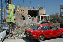
 Posters on Tayibe village walls after the 2006 Lebanon War | |
| Coordinates: 33°16′35″N 35°31′14″E / 33.27639°N 35.52056°E | |
| Grid position | 198/297 PAL |
| Country | |
| Governorate | Nabatieh Governorate |
| District | Marjeyoun District |
| Elevation | 660 m (2,170 ft) |
| Time zone | UTC+2 (EET) |
| • Summer (DST) | UTC+3 (EEST) |
| Dialing code | +961 |
Et Taibeh | |
 | |
| Alternative name | Et Tayibe |
|---|---|
| Location | 2 kilometres (1.2 mi) south of the Litani River |
| History | |
| Periods | Heavy Neolithic |
| Cultures | Qaraoun culture |
| Site notes | |
| Archaeologists | Louis Dubertret and Jacques Cauvin |
| Public access | Unknown |
Tayibe, Et Tayibe or Et Taibeh is a village in the Marjeyoun District in south Lebanon.
