| Tayura Таюра | |
|---|---|
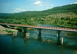
 Bridge over the Tayura near Zvyozdny | |
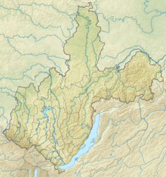
Mouth location in Irkutsk Oblast, Russia | |
| Location | |
| Country | Russia |
| Physical characteristics | |
| Source | |
| • location | Lena-Angara Plateau |
| • coordinates | 55°53′02″N 106°44′40″E / 55.88389°N 106.74444°E |
| • elevation | 814 m (2,671 ft) |
| Mouth | Lena |
• location | Near Ust-Kut |
• coordinates | 57°00′10″N 106°32′44″E / 57.00278°N 106.54556°E |
• elevation | 269 m (883 ft) |
| Length | 216 km (134 mi) |
| Basin size | 5,720 km2 (2,210 sq mi) |
| Discharge | |
| • average | 43.92 m3/s (1,551 cu ft/s) |
| Basin features | |
| Progression | Lena→ Laptev Sea |
The Tayura (Russian: Таюра) is a river in Irkutsk Oblast, Russia. It is a tributary of the Lena with a length of 216 kilometres (134 mi) and a drainage basin area of 5,720 square kilometres (2,210 sq mi).[1] The river is crossed by the Baikal-Amur Mainline and the interregional highway 25K-258 Ust-Kut - Severobaikalsk.[2]
The Tayura basin is one of the areas of Russia traditionally inhabited by Evenks. The abandoned Evenk settlement of Aitkan was located by the river, 22 kilometres (14 mi) east of Omoloy village on the Lena.[3][4]
- ^ "Река Таюра in the State Water Register of Russia". textual.ru (in Russian).
- ^ Cite error: The named reference
GЕwas invoked but never defined (see the help page). - ^ "O-48 Chart (in Russian)". Retrieved 30 November 2021.
- ^ "N-48 Chart (in Russian)". Retrieved 2 December 2021.
