| Taz Таз | |
|---|---|
 View of the river | |
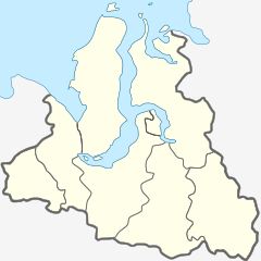
Mouth location in the Yamalo-Nenets Autonomous Okrug, Russia | |
| Location | |
| Country | Yamalo-Nenets Autonomous Okrug, Russia |
| Physical characteristics | |
| Source | |
| • location | Siberian Uvaly |
| • coordinates | 62°37′6″N 84°09′51″E / 62.61833°N 84.16417°E |
| • elevation | 139 m (456 ft) |
| Mouth | |
• location | Taz Estuary |
• coordinates | 67°34′46″N 78°09′34″E / 67.5794°N 78.1595°E |
• elevation | 0 m (0 ft) |
| Length | 1,401 km (871 mi) |
| Basin size | 150,000 km2 (58,000 sq mi) |
| Discharge | |
| • average | 1,450 m3/s (51,000 cu ft/s) |
The Taz (Russian: Таз) is a river located in western Siberia, has a length of 1,401 kilometers (871 mi) and drains a basin estimated at 150,000 square kilometers (58,000 sq mi).[1] Its middle and lower course are located within Yamalo-Nenets Autonomous Okrug, while its upper course borders with Krasnoyarsk Krai.
The now ruined city of Mangazeya was located by the Taz.
