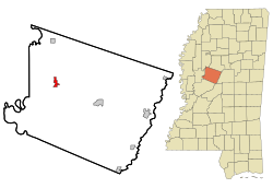
Tchula, Mississippi | |
|---|---|
 Location of Tchula, Mississippi | |
| Coordinates: 33°10′51″N 90°13′21″W / 33.18083°N 90.22250°W | |
| Country | United States |
| State | Mississippi |
| County | Holmes |
| Area | |
• Total | 1.44 sq mi (3.73 km2) |
| • Land | 1.41 sq mi (3.65 km2) |
| • Water | 0.03 sq mi (0.09 km2) |
| Elevation | 112 ft (34 m) |
| Population (2020) | |
• Total | 1,652 |
| • Density | 1,173.30/sq mi (452.90/km2) |
| Time zone | UTC-6 (Central (CST)) |
| • Summer (DST) | UTC-5 (CDT) |
| ZIP code | 39169 |
| Area code | 662 |
| FIPS code | 28-72440 |
| GNIS feature ID | 0678607 |
Tchula is a town in Holmes County, Mississippi, United States. The population was 1,650 at the 2020 census,[2] down from 2,332 in 2000.
A 2015 article in The Guardian described it as the poorest community in the United States.[3]
- ^ "2020 U.S. Gazetteer Files". United States Census Bureau. Retrieved July 24, 2022.
- ^ "Geographic Identifiers: 2010 Census Summary File 1 (G001): Tchula town, Mississippi". American Factfinder. U.S. Census Bureau. Archived from the original on February 13, 2020. Retrieved August 18, 2017.
- ^ McGreal, Chris (November 15, 2015). "Poorest town in poorest state: Segregation is gone but so are the jobs". The Guardian. Retrieved July 9, 2017.
