| Tea Tree Gully Adelaide, South Australia | |||||||||||||||
|---|---|---|---|---|---|---|---|---|---|---|---|---|---|---|---|
 | |||||||||||||||
| Coordinates | 34°49′30″S 138°43′53″E / 34.825007°S 138.731298°E[1] | ||||||||||||||
| Population | 3,499 (SAL 2021)[2] | ||||||||||||||
| Postcode(s) | 5091 | ||||||||||||||
| Time zone | ACST (UTC+9:30) | ||||||||||||||
| • Summer (DST) | ACST (UTC+10:30) | ||||||||||||||
| Location | 22 km (14 mi) from Adelaide CBD | ||||||||||||||
| LGA(s) | City of Tea Tree Gully | ||||||||||||||
| Region | Northern Adelaide | ||||||||||||||
| County | Adelaide | ||||||||||||||
| State electorate(s) | Newland | ||||||||||||||
| Federal division(s) | Makin | ||||||||||||||
| |||||||||||||||
| Footnotes | Adjoining suburbs[1] | ||||||||||||||
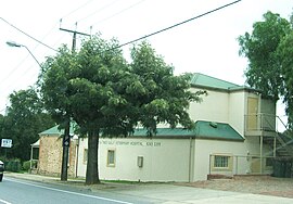
Tea Tree Gully (TTG) is a suburb in the greater Adelaide, South Australia area, under the City of Tea Tree Gully. Tea Tree Gully is in the City of Tea Tree Gully local government area, the South Australian House of Assembly electoral district of Newland and the Australian House of Representatives Division of Makin.
- ^ a b "Search results for 'Tea Tree Gully, SUB' with the following datasets selected – 'Suburbs and localities', 'Counties', 'Local Government Areas', 'SA Government Regions' and 'Gazetteer'". Location SA Map Viewer. South Australian Government. Retrieved 3 September 2021.
- ^ Australian Bureau of Statistics (28 June 2022). "Tea Tree Gully (suburb and locality)". Australian Census 2021 QuickStats. Retrieved 28 June 2022.
