Tecumseh, Oklahoma | |
|---|---|
 Tecumseh City Hall | |
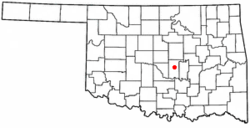
 Location of Tecumseh, Oklahoma | |
| Coordinates: 35°15′44″N 96°56′01″W / 35.26222°N 96.93361°W | |
| Country | United States |
| State | Oklahoma |
| County | Pottawatomie |
| Government | |
| • Type | Council-Manager |
| • City Council | Eddy Parker, Mayor Linda Farris, Ward 1 Sharon Stewart, Ward 2 Linda Praytor, Ward 3 John Collier, Ward 4 |
| Area | |
| • Total | 15.25 sq mi (39.50 km2) |
| • Land | 15.02 sq mi (38.90 km2) |
| • Water | 0.23 sq mi (0.60 km2) |
| Elevation | 1,037 ft (316 m) |
| Population (2020) | |
| • Total | 6,302 |
| • Density | 419.60/sq mi (162.01/km2) |
| Time zone | UTC-6 (Central (CST)) |
| • Summer (DST) | UTC-5 (CDT) |
| ZIP code | 74873 |
| Area code(s) | 405/572 |
| FIPS code | 40-72650[3] |
| GNIS feature ID | 2412040[2] |
| Website | City website |
Tecumseh (Meskwaki: Takamithîheki[4]) is a city in Pottawatomie County, Oklahoma. The population was 6,302 by the 2020 United States census.[5] It was named for the noted Shawnee chief, Tecumseh. The locale was designated as the county seat at Oklahoma's statehood, but a county-wide election moved the seat to Shawnee in 1930.[6]
- ^ "ArcGIS REST Services Directory". United States Census Bureau. Retrieved September 20, 2022.
- ^ a b U.S. Geological Survey Geographic Names Information System: Tecumseh, Oklahoma
- ^ "U.S. Census website". United States Census Bureau. Retrieved January 31, 2008.
- ^ Gordon Whittaker, 2005, "A Concise Dictionary of the Sauk Language", The Sac & Fox National Public Library Stroud, Oklahoma. [1]
- ^ "Tecumseh (city), Oklahoma". United States Census Bureau. Retrieved March 23, 2024.
- ^ Glenn Dale Carter and Don Holland, "Tecumseh." Encyclopedia of Oklahoma History and Culture. Accessed May 22, 2015.