Teddington | |
|---|---|
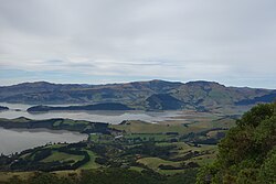
 Looking northeast, with Head of the Bay in the lower left of the picture and Te Wharae / Charteris Bay in the centre | |
 | |
| Coordinates: 43°40′06.24″S 172°39′40.81″E / 43.6684000°S 172.6613361°E | |
| Country | New Zealand |
| Region | Canterbury |
| Local authority | Christchurch City Council |
| Ward | Banks Peninsula |
| Community | Te Pātaka o Rākaihautū Banks Peninsula |
| Electorates |
|
| Government | |
| • Territorial Authority | Christchurch City Council |
| • Regional council | Environment Canterbury |
| • Mayor of Christchurch | Phil Mauger |
| • Banks Peninsula MP | Vanessa Weenink |
| • Te Tai Tonga MP | Tākuta Ferris |
| Area | |
| • Total | 47.42 km2 (18.31 sq mi) |
| Population (June 2023)[2] | |
| • Total | 270 |
| • Density | 5.7/km2 (15/sq mi) |
| Time zone | UTC+12 (NZST) |
| • Summer (DST) | UTC+13 (NZDT) |
Teddington is a very small community on Banks Peninsula at the head of Lyttelton Harbour / Whakaraupō. It sits on the junction of the road to Gebbies Pass and the road from Purau to Christchurch.
It dates back to the early settlers of Christchurch[3] but is now reduced to a pub and a restored working blacksmith's forge.[4]
- ^ Cite error: The named reference
Areawas invoked but never defined (see the help page). - ^ "Population estimate tables - NZ.Stat". Statistics New Zealand. Retrieved 25 October 2023.
- ^ "Teddington". Victoria University of Wellington. 2008. Retrieved 7 November 2019.
- ^ "Unexpected Places -The blacksmith at Teddington". Stuff.co.nz. 8 April 2018. Retrieved 7 November 2019.