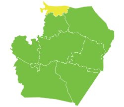
Tell Abyad District
منطقة تل أبيض | |
|---|---|
 Location of Tell Abyad District within Raqqa Governorate | |
| Coordinates (Tell Abyad): 36°41′51″N 38°57′24″E / 36.6975°N 38.9567°E | |
| Country | |
| Governorate | Raqqa |
| Seat | Tell Abyad |
| Subdistricts | 3 nawāḥī |
| Area | |
• Total | 4,834.02 km2 (1,866.43 sq mi) |
| Population (2004)[1] | 129,714 |
| Geocode | SY1102 |
Tell Abyad District (Arabic: منطقة تل أبيض, romanized: Manṭiqat Tall Abyaḍ; Kurdish: Devera Girê Spî) is a district of the Raqqa Governorate in northern Syria. The administrative centre is the city of Tell Abyad. Parts of the district are currently under the Turkish occupation of northern Syria.[2]
The administrative center of Tell Abyad District and Tell Abyad Subdistrict shown above is the city of Tell Abyad.
The administrative center of Suluk Subdistrict shown above is the city of Suluk.
The administrative center of Ayn Issa Subdistrict shown above is the city of Ayn Issa.
- ^ "General Census of Population and Housing 2004" (PDF) (in Arabic). Syrian Central Bureau of Statistics. Archived from the original (PDF) on 8 December 2015. Retrieved 15 October 2015. Also available in English: "2004 Census Data". UN OCHA. Retrieved 15 October 2015.
- ^ "Turkey provokes our forces in Tel Abyad and Ras al-Ain: SDF". North Press Agency. 2021-11-10. Retrieved 2021-12-28.


