| Temblor Range | |
|---|---|
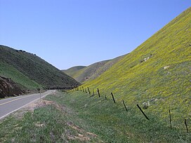
 Temblor Mountains in spring; view from near State Route 58 summit | |
| Highest point | |
| Elevation | 1,176 m (3,858 ft) |
| Geography | |
location of Temblor Range in California[1] | |
| Country | United States |
| State | California |
| District | San Luis Obispo County & Kern County |
| Range coordinates | 35°19′25.877″N 119°47′48.469″W / 35.32385472°N 119.79679694°W |
| Parent range | California Coast Ranges |
| Borders on | San Emigdio Mountains and Diablo Range |
| Topo map | USGS McKittrick Summit |
| Biome | California interior chaparral and woodlands |
The Temblor Range is a mountain range within the California Coast Ranges, at the southwestern extremity of the San Joaquin Valley in California in the United States. It runs in a northwest-southeasterly direction along the borders of Kern County and San Luis Obispo County. The name of the range is from Spanish temblor meaning "tremor", referring to earthquakes. The San Andreas Fault Zone runs parallel to the range at the base of its western slope, on the eastern side of the Carrizo Plain, while the Antelope Plain, location of the enormous Midway Sunset, South Belridge, and Cymric oil fields, lies to the northeast.
Peaks within the Temblor Range average about 3,500 ft (1,100 m) above sea level.[2] The highest point is McKittrick Summit at 4,331 ft (1,320 m), located in the center of the range about 35 mi (56 km) west of Bakersfield.[3] The summit on State Route 58, which crosses the range, is at 3,750 feet (1,140 m) above sea level. The lowest crossing of the range is at Polonio Pass at 1,407 feet (429 m) by State Route 46 at its northern end and is separated by the Diablo Range to the north near Cholame.
