Temple, Maine | |
|---|---|
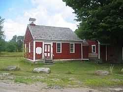
 Temple Historical Society, formerly the historic No. 5 Schoolhouse | |
| Coordinates: 44°40′53″N 70°15′35″W / 44.68139°N 70.25972°W | |
| Country | United States |
| State | Maine |
| County | Franklin |
| Villages | Temple Temple Intervale |
| Area | |
• Total | 35.76 sq mi (92.62 km2) |
| • Land | 35.53 sq mi (92.02 km2) |
| • Water | 0.23 sq mi (0.60 km2) |
| Elevation | 1,230 ft (375 m) |
| Population (2020) | |
• Total | 527 |
| • Density | 15/sq mi (5.7/km2) |
| Time zone | UTC-5 (Eastern (EST)) |
| • Summer (DST) | UTC-4 (EDT) |
| ZIP code | 04984 |
| Area code | 207 |
| FIPS code | 23-75980 |
| GNIS feature ID | 0582761 |
| Website | townoftemple |
Temple is a town in Franklin County, Maine, United States. The town was named after Temple, New Hampshire.[2] It is located at the end of Maine State Route 43 (Temple Road), and is said to be one of only two towns in Maine to be situated at the end of a public highway.[3] The population was 527 at the 2020 census.[4]
- ^ Cite error: The named reference
Gazetteer fileswas invoked but never defined (see the help page). - ^ "Profile for Temple, Maine". ePodunk. Retrieved April 18, 2010.
- ^ Maine Times, 1970s
- ^ "Census - Geography Profile: Temple town, Franklin County, Maine". Retrieved January 30, 2022.

