Tendring District | |
|---|---|
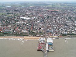
 Clacton-on-Sea, the administrative centre of the district | |
| Motto(s): | |
 Tendring shown within Essex | |
| Coordinates: 51°47′N 1°08′E / 51.783°N 1.133°E | |
| Sovereign state | United Kingdom |
| Country | England |
| Region | East of England |
| County | Essex |
| Incorporated | 1 April 1974 |
| Named for | Tendring Hundred |
| Administrative HQ | Clacton-on-Sea |
| Government | |
| • Type | Non-metropolitan district |
| • Body | Tendring District Council |
| • Executive | Leader and cabinet |
| • Control | No overall control |
| • Leader | Mark Stephenson (Ind.) |
| • Chair | Dan Casey |
| • MPs | |
| Area | |
| • Total | 141 sq mi (366 km2) |
| • Land | 130 sq mi (336 km2) |
| • Rank | 110th |
| Population (2022)[3] | |
| • Total | 151,451 |
| • Rank | 145th |
| • Density | 1,200/sq mi (450/km2) |
| Ethnicity (2021) | |
| • Ethnic groups | |
| Religion (2021) | |
| • Religion | List
|
| Time zone | UTC+0 (GMT) |
| • Summer (DST) | UTC+1 (BST) |
| Postcode areas | |
| Dialling codes | 01255 |
| GSS code | E07000076 |
| Website | tendringdc |
Tendring District Council | |
|---|---|
 | |
| Type | |
| Type | |
| Leadership | |
Ian Davidson since 1 December 2010[6] | |
| Structure | |
| Seats | 48 councillors |
Political groups |
|
| Elections | |
| First-past-the-post | |
Last election | 4 May 2023 |
Next election | 6 May 2027 |
| Meeting place | |
 | |
| Town Hall, Station Road, Clacton-on-Sea, Essex, CO15 1SE | |
| Website | |
| www | |
Tendring District is a local government district in north-east Essex, England. Its council is based in Clacton-on-Sea, the largest town. Other towns are Brightlingsea, Harwich, Frinton-on-Sea and Walton-on-the-Naze.
The district borders the City of Colchester to the west and the Babergh District of Suffolk, across the estuary of the River Stour, to the north. To the east and south, it faces the North Sea, with the estuary of the River Colne to the south-west. The area is sometimes referred to as the Tendring Peninsula.
The modern local government district was formed in 1974. The name Tendring comes from the ancient Tendring Hundred which was named after the small village of Tendring.
- ^ "Meetings, agendas and minutes". Tendring District Council. Retrieved 3 June 2024.
- ^ "Mid-Year Population Estimates, UK, June 2022". Office for National Statistics. 26 March 2024. Retrieved 3 May 2024.
- ^ "Mid-Year Population Estimates, UK, June 2022". Office for National Statistics. 26 March 2024. Retrieved 3 May 2024.
- ^ a b UK Census (2021). "2021 Census Area Profile – Tendring Local Authority (E07000076)". Nomis. Office for National Statistics. Retrieved 3 June 2024.
- ^ "Chairman of the Council". Tendring District Council. Retrieved 11 May 2024.
- ^ "Council minutes, 5 January 2022". Tendring District Council. Retrieved 8 June 2023.