Tenza | |
|---|---|
Municipality and town | |
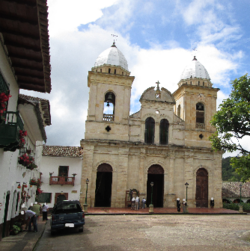
 Church of Tenza | |
 Location of the municipality and town of Tenza in the Boyacá Department of Colombia | |
| Country | |
| Department | Boyacá Department |
| Province | Eastern Boyacá Province |
| Founded | 24 June 1537 |
| Founded by | Pedro Fernández de Valenzuela |
| Government | |
| • Mayor | Jose Luis Gómez Alfonso (2020-2023) |
| Area | |
• Municipality and town | 51 km2 (20 sq mi) |
| Elevation | 1,600 m (5,200 ft) |
| Population (2015) | |
• Municipality and town | 4,112 |
| • Density | 81/km2 (210/sq mi) |
| • Urban | 1,229 |
| Time zone | UTC-5 (Colombia Standard Time) |
| Website | Official website |
Tenza (Spanish pronunciation: [ˈtensa]) is a town and municipality in the subregion of the Eastern Boyacá Province of the Colombian department Boyacá. Tenza borders La Capilla and Pachavita in the north, in the east the department of Cundinamarca, in the south with Sutatenza and in the east with Garagoa. The altitude of the municipality in the Tenza Valley ranges from 1,600 metres (5,200 ft) to 2,200 metres (7,200 ft).[1]
- ^ (in Spanish) Official website Tenza - accessed 07-05-2016
