Tenzing-Hillary Airport तेन्जिङ हिलारी विमानस्थल | |||||||||||
|---|---|---|---|---|---|---|---|---|---|---|---|
 | |||||||||||
| Summary | |||||||||||
| Airport type | Public | ||||||||||
| Owner | Government of Nepal | ||||||||||
| Operator | Civil Aviation Authority of Nepal | ||||||||||
| Serves | Lukla, Nepal | ||||||||||
| Hub for | |||||||||||
| Time zone | NST (UTC+05:45) | ||||||||||
| Elevation AMSL | 9,337 ft / 2,846 m | ||||||||||
| Coordinates | 27°41′16″N 086°43′53″E / 27.68778°N 86.73139°E | ||||||||||
| Website | lukla | ||||||||||
| Map | |||||||||||
| Runways | |||||||||||
| |||||||||||
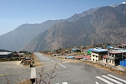
Tenzing-Hillary Airport (Nepali: तेन्जिङ हिलारी विमानस्थल, IATA: LUA, ICAO: VNLK), also known as Lukla Airport, is a domestic airport and altiport in the town of Lukla,[2] in Khumbu Pasanglhamu, Solukhumbu District, Koshi Province of Nepal. It gained worldwide fame as it was rated the most dangerous airport in the world for more than 20 years by a program titled Most Extreme Airports, broadcast on The History Channel in 2010.[3]
The airport is popular because it is considered the starting point for treks towards Mount Everest Base Camp. There are daily flights between Lukla and Kathmandu during daylight hours in good weather. Although the flying distance is short, rain commonly occurs in Lukla while the sun is shining brightly in Kathmandu. High winds, cloud cover, and changing visibility often mean flights can be delayed or the airport closed.[3] The airport is contained within a chain-link fence and is patrolled by the Nepali armed police or civil police around the clock for security.[citation needed]
- ^ Cite error: The named reference
CAANwas invoked but never defined (see the help page). - ^ a b Airport information for Lukla, Nepal – Tenzing–Hillary Airport (VNLK / LUA) at Great Circle Mapper.
- ^ a b "Most Extreme Airports". History Specials. Season 1. Episode 104. The History Channel. 26 August 2010.
