This article needs additional citations for verification. (October 2013) |
Teresa | |
|---|---|
| Municipality of Teresa | |
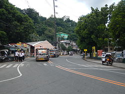
 Manila East Road | |
 Map of Rizal with Teresa highlighted | |
Location within the Philippines | |
| Coordinates: 14°33′31″N 121°12′30″E / 14.55861°N 121.20833°E | |
| Country | Philippines |
| Region | Calabarzon |
| Province | Rizal |
| District | 2nd district |
| Founded | 1853 |
| Annexation to Antipolo | October 12, 1903 |
| Chartered | January 1, 1919 |
| Named for | Doña Teresa Candelaria |
| Barangays | 9 (see Barangays) |
| Government | |
| • Type | Sangguniang Bayan |
| • Mayor | Rodel N. Dela Cruz |
| • Vice Mayor | Freddie F. Bonifacio |
| • Representative | Emigdio P. Tanjuatco III |
| • Municipal Council | Members |
| • Electorate | 46,107 voters (2022) |
| Area | |
• Total | 18.61 km2 (7.19 sq mi) |
| Elevation | 116 m (381 ft) |
| Highest elevation | 304 m (997 ft) |
| Lowest elevation | 2 m (7 ft) |
| Population (2020 census)[3] | |
• Total | 64,072 |
| • Density | 3,400/km2 (8,900/sq mi) |
| • Households | 14,731 |
| Economy | |
| • Income class | 2nd municipal income class |
| • Poverty incidence | 5.70 |
| • Revenue | ₱ 242.1 million (2020) |
| • Assets | ₱ 514.8 million (2020) |
| • Expenditure | ₱ 215.5 million (2020) |
| • Liabilities | ₱ 169.6 million (2020) |
| Service provider | |
| • Electricity | Manila Electric Company (Meralco) |
| Time zone | UTC+8 (PST) |
| ZIP code | 1880 |
| PSGC | |
| IDD : area code | +63 (0)2 |
| Native languages | Tagalog |
| Website | teresarizal |
Teresa, officially the Municipality of Teresa (Tagalog: Bayan ng Teresa), is a 2nd class municipality in the province of Rizal, Philippines. According to the 2020 census, it has a population of 64,072 people.[3]
It is situated in the slopes of the Sierra Madre Mountains and is landlocked on four corners by Antipolo on the north, Angono on the west, Tanay, on the east, and Morong, on the south.
Most of the people here are Tagalogs. Teresa is primarily known for the nearby mountain resorts, Villa Sampaguita Resort and Real Cove Resort (Formerly Sunrise Resort, Sunset Resort, and Terra Villa Resort). Contrary to some articles, Teresa is actually a valley surrounded by mountains. The town center is located almost at the center of the valley. In an aerial view of Teresa, one would notice the previously vast expanse of agricultural land bordered by marble-rich mountains.
The town is passed by motorists bounded for the more inland towns of Morong, Baras, Tanay, Pililla, and Laguna and Quezon provinces.
Land uses (in hectares): Commercial (1.92), Residential (104.32), Agricultural (1183.35), Protected areas (13,952.41), Industrial / Ecozone (710.69), Institutional (112.28), and Special / Other uses (123.03).
The town's festivals are the Turumba sa Mahal na Patron Santa Rosa (held every August 23), Anniversary celebration of town independence (every December 30), and Town fiesta (every 1st Sunday of March).
- ^ Municipality of Teresa | (DILG)
- ^ "2015 Census of Population, Report No. 3 – Population, Land Area, and Population Density" (PDF). Philippine Statistics Authority. Quezon City, Philippines. August 2016. ISSN 0117-1453. Archived (PDF) from the original on May 25, 2021. Retrieved July 16, 2021.
- ^ a b Census of Population (2020). "Region IV-A (Calabarzon)". Total Population by Province, City, Municipality and Barangay. Philippine Statistics Authority. Retrieved 8 July 2021.
- ^ "PSA Releases the 2021 City and Municipal Level Poverty Estimates". Philippine Statistics Authority. 2 April 2024. Retrieved 28 April 2024.


