Native name: Terre-de-Haut des Saintes | |||||||||||||
|---|---|---|---|---|---|---|---|---|---|---|---|---|---|
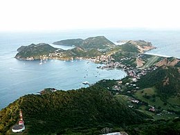
 Terre-de-Haut view from Chameau hill. | |||||||||||||
 Terre-de-Haut Island on the right | |||||||||||||
| Geography | |||||||||||||
| Location | Caribbean Sea | ||||||||||||
| Coordinates | 15°51′45″N 61°35′00″W / 15.86250°N 61.58333°W | ||||||||||||
| Archipelago | Îles des Saintes | ||||||||||||
| Area | 5.2 km2 (2.0 sq mi) | ||||||||||||
| Highest elevation | 306 m (1004 ft) | ||||||||||||
| Highest point | Chameau hill | ||||||||||||
| Administration | |||||||||||||
| Overseas department | Guadeloupe | ||||||||||||
| Canton | Trois-Rivières | ||||||||||||
| commune | Terre-de-Haut | ||||||||||||
| Capital city | Fond-du-Curé | ||||||||||||
| Largest settlement | Fond-du-Curé | ||||||||||||
| Mayor | Louis Molinié | ||||||||||||
| Demographics | |||||||||||||
| Population | 1532 (2017) | ||||||||||||
| Pop. density | 255/km2 (660/sq mi) | ||||||||||||
| Additional information | |||||||||||||
| |||||||||||||
Terre-de-Haut Island (French pronunciation: [tɛʁ də ʔo]; Guadeloupean Creole: Tèdého; also formerly known as Petite Martinique) is the easternmost island in the Îles des Saintes, part of the archipelago of Guadeloupe. Like name of neighboring Terre-de-Bas Island, name Terre-de-Haut comes from the maritime vocabulary, which called the islands exposed to the "highland" winds and those protected from the wind, "lowlands".


