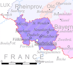
Territory of the Saar Basin | |||||||||||||||
|---|---|---|---|---|---|---|---|---|---|---|---|---|---|---|---|
| 1920–1935 | |||||||||||||||
Maps of the Territory of the Saar Basin -The Saar Basin (red) -The Saar Basin (purple) | |||||||||||||||
| Status | Territory under League of Nations protection | ||||||||||||||
| Capital | Saarbrücken | ||||||||||||||
| Common languages | French German Rhine Franconian Moselle Franconian | ||||||||||||||
| Government | Special territory | ||||||||||||||
| Commission Chairman | |||||||||||||||
• 1920–1926 | Victor Rault | ||||||||||||||
• 1926–1927 | G. W. Stephens | ||||||||||||||
• 1927–1932 | Ernest Wilton | ||||||||||||||
• 1932–1935 | Geoffrey Knox | ||||||||||||||
| President of the Landesrat | |||||||||||||||
• 1922–1924 | B. Koßmann | ||||||||||||||
• 1924–1935 | Peter Scheuer | ||||||||||||||
| Historical era | Interwar period | ||||||||||||||
• Treaty of Versailles took effect | 10 January 1920 | ||||||||||||||
| 13 January 1935 | |||||||||||||||
• Disestablished | 1 March 1935 | ||||||||||||||
| Population | |||||||||||||||
• 1933 | 812,000 | ||||||||||||||
| Currency | Saar franc | ||||||||||||||
| |||||||||||||||
| Today part of | Germany | ||||||||||||||
The Territory of the Saar Basin (German: Saarbeckengebiet, Saarterritorium;[1] French: Territoire du bassin de la Sarre) was a region occupied and governed by the United Kingdom and France from 1920 to 1935 under a League of Nations mandate. It had its own flag (adopted on 28 July 1920): a blue, white, and black horizontal tricolour. The blue and white stood for Bavaria, and white and black for Prussia, out of whose lands the Saar Territory was formed. Initially, the occupation was under the auspices of the Treaty of Versailles.[2] Its population in 1933 was 812,000, and its capital was Saarbrücken.[3] The territory closely corresponds with the modern German state of Saarland, but was slightly smaller in area.[4] After a plebiscite was held in 1935, it was returned to Germany.[5]
- ^ 1952 (in German). Walter de Gruyter. 1 January 2000. ISBN 978-3-4867-1832-4.
- ^ Article 45-50 with Annex, Treaty of Versailles
- ^ "Saarland: Heads of Administration: 1920–1935". Archontology.org. Retrieved 20 November 2018.
- ^ The extent of the territory is specified in Article 48, Treaty of Versailles
- ^ Stahn, Carsten (2008). The Law and Practice of International Territorial Administration. doi:10.1017/CBO9780511585937. ISBN 978-0-521-87800-5.


