Terryville, Connecticut | |
|---|---|
 Main Street (U.S. Route 6) in Terryville | |
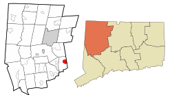
 Location in Litchfield County, Connecticut | |
| Coordinates: 41°40′41″N 73°0′39″W / 41.67806°N 73.01083°W | |
| Country | |
| State | |
| County | Litchfield |
| Town | Plymouth |
| Area | |
| • Total | 7.22 km2 (2.79 sq mi) |
| • Land | 7.15 km2 (2.76 sq mi) |
| • Water | 0.07 km2 (0.03 sq mi) |
| Elevation | 187 m (615 ft) |
| Population (2010) | |
| • Total | 5,387 |
| • Density | 753.5/km2 (1,952/sq mi) |
| Time zone | UTC−5 (Eastern) |
| • Summer (DST) | UTC−4 (Eastern) |
| ZIP Code | 06786 |
| Area code(s) | 860 |
Terryville is a census-designated place (CDP) in Litchfield County, Connecticut, United States, and is the largest village within the town of Plymouth. In the 2010 census, Terryville had a population of 5,387,[1] out of 12,243 in the entire town of Plymouth. The village is named for Eli Terry Jr., the son of the well-known clockmaker Eli Terry Sr. Terryville is also home to the Lock Museum of America. There is a water wheel located in downtown Terryville that is dedicated to the son of Eli Terry Sr.
- ^ "Geographic Identifiers: 2010 Census Summary File 1 (G001), Terryville CDP, Connecticut". American FactFinder. U.S. Census Bureau. Archived from the original on February 13, 2020. Retrieved October 31, 2019.