Tetonia, Idaho | |
|---|---|
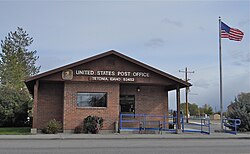
 Tetonia Post Office, October 2013 | |
 Location of Tetonia in Teton County, Idaho. | |
| Coordinates: 43°48′50″N 111°9′35″W / 43.81389°N 111.15972°W | |
| Country | United States |
| State | Idaho |
| County | Teton |
| Area | |
• Total | 0.57 sq mi (1.47 km2) |
| • Land | 0.57 sq mi (1.47 km2) |
| • Water | 0.00 sq mi (0.00 km2) |
| Elevation | 6,047 ft (1,843 m) |
| Population | |
• Total | 269 |
• Estimate (2019)[3] | 288 |
| • Density | 507.04/sq mi (195.61/km2) |
| Time zone | UTC-7 (Mountain (MST)) |
| • Summer (DST) | UTC-6 (MDT) |
| ZIP codes | 83424, 83452 |
| Area code(s) | 208, 986 |
| FIPS code | 16-80470 |
| GNIS feature ID | 0398229 |
| Website | tetoniaidaho |
Tetonia is a city in Teton County, Idaho, United States, about 50 miles (80 km) northeast of Idaho Falls, Idaho (center to center) and about 425 miles (684 km) northwest of Denver, Colorado. The population was 269 at the 2010 census.
- ^ "2019 U.S. Gazetteer Files". United States Census Bureau. Retrieved July 9, 2020.
- ^ Cite error: The named reference
wwwcensusgovwas invoked but never defined (see the help page). - ^ Cite error: The named reference
USCensusEst2019CenPopScriptOnlyDirtyFixDoNotUsewas invoked but never defined (see the help page).