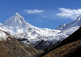
| Thalay Sagar | |
|---|---|
 View of Thalaysagar en route Kedartal | |
| Highest point | |
| Elevation | 6,904 m (22,651 ft)[1] |
| Prominence | 1,000 m (3,280 ft)[2] |
| Coordinates | 30°51′29″N 78°59′50″E / 30.85806°N 78.99722°E[1] |
| Geography | |
| Location | Uttarakhand, India |
| Parent range | Gangotri Group, Garhwal Himalayas |
| Climbing | |
| First ascent | 24 June 1979 by Roy Kligfield, John Thackray, Pete Thexton[3] |
| Easiest route | Northwest couloir and ridge: technical rock/snow/ice climb |
Thalay Sagar is a mountain in the Gangotri Group of peaks in the western Garhwal Himalayas, on the main ridge that lies south of the Gangotri Glacier. It lies in the northern Indian state of Uttarakhand, 10 kilometres (6 mi) southwest of the Hindu holy site of Gaumukh (the source of the Bhagirathi River). It is the second highest peak on the south side of the Gangotri Glacier (after Kedarnath), but it is more notable for being a dramatic rock peak, steep on all sides, and a famed prize for mountaineers. It is adjacent to the Jogin group of peaks, and has the lake Kedartal at its base.
- ^ a b H. Adams Carter, "Classification of the Himalaya", American Alpine Journal, 1985, p. 140.
- ^ Corrected version of SRTM data, available at Viewfinder Panoramas
- ^ Andy Fanshawe and Stephen Venables, Himalaya Alpine-Style, Hodder and Stoughton, 1995, ISBN 0-340-64931-3, pp. 108–111.
