| Thanington | |
|---|---|
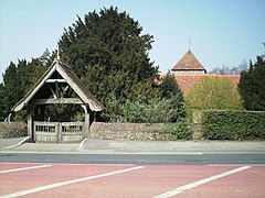
 St Nicholas' Church | |
Location within Kent | |
| Area | 4.8 km2 (1.9 sq mi) |
| Population | 2,662 (Civil Parish 2011)[1] |
| • Density | 555/km2 (1,440/sq mi) |
| Civil parish | |
| District | |
| Shire county | |
| Region | |
| Country | England |
| Sovereign state | United Kingdom |
| Post town | Canterbury |
| Postcode district | CT1, CT4 |
| Dialling code | 01227 |
| Police | Kent |
| Fire | Kent |
| Ambulance | South East Coast |
| UK Parliament |
|
Thanington is a civil parish on the west edge of Canterbury, Kent, United Kingdom. It extends to the south-west of A2 from Wincheap to the Milton Bridge in Chartham. In 2011 the parish had a population of 2662.
The north ward of Thanington Without follows the River Stour nearest to the city centre and London railway line, it has private housing north of Ashford Road and a large estate of mixed housing south of Ashford Road. Stuppington to the south is a linear settlement along New House Lane, New House Close and Iffin Lane. The parish church is dedicated to St Nicholas.[2] The current civil parish was renamed from "Thanington Without" to "Thanington" on 1 April 2019.[3]
- ^ Key Statistics; Quick Statistics: Population Density United Kingdom Census 2011 Office for National Statistics Retrieved 21 November 2013
- ^ "Parishes: Thanington | British History Online". www.british-history.ac.uk. Retrieved 19 February 2018.
- ^ "The Canterbury City Council (Reorganisation of Community Governance) Order 2018" (PDF). Local Government Boundary Commission for England. Retrieved 15 May 2019.
