The Fens | |
|---|---|
 | |
![Map of the Fens within eastern England along with the major settlements, rivers and drains within it.[1]](http://upload.wikimedia.org/wikipedia/commons/thumb/2/25/The_Fens_England_map.svg/250px-The_Fens_England_map.svg.png) Map of the Fens within eastern England along with the major settlements, rivers and drains within it.[1] | |
| Country | United Kingdom |
| Constituent country | England |
| Region | East of England East Midlands |
| Counties | Lincolnshire, Cambridgeshire, Norfolk Suffolk |
| Area | |
• Total | 1,500 sq mi (3,900 km2) |
| Time zone | UTC±0 (Greenwich Mean Time) |
| • Summer (DST) | UTC+1 (British Summer Time) |
| Website | visitcambridgeshirefens |

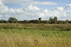
The Fens or Fenlands in eastern England are a naturally marshy region supporting a rich ecology and numerous species. Most of the fens were drained centuries ago, resulting in a flat, dry, low-lying agricultural region supported by a system of drainage channels and man-made rivers (dykes and drains) and automated pumping stations. There have been unintended consequences to this reclamation, as the land level has continued to sink and the dykes have been built higher to protect it from flooding.
Fen is the local term for an individual area of marshland or former marshland. It also designates the type of marsh typical of the area, which has neutral or alkaline water and relatively large quantities of dissolved minerals, but few other plant nutrients.
The Fens are a National Character Area,[2] based on their landscape, biodiversity, geodiversity and economic activity.
The Fens lie inland of the Wash, and are an area of nearly 1,500 sq mi (3,900 km2) in the south east of Lincolnshire, most of Cambridgeshire (which also includes parts of the old historic county of Huntingdonshire), and western most parts of Norfolk and Suffolk.[3]
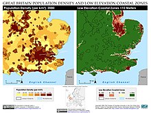
Most of the Fens lie within a few metres of sea level. As with similar areas in the Netherlands, much of the Fenland originally consisted of fresh- or salt-water wetlands. These have been artificially drained and continue to be protected from floods by drainage banks and pumps. With the support of this drainage system, the Fenland has become a major arable agricultural region for grains and vegetables. The Fens are particularly fertile, containing around half of the grade 1 agricultural land in England.[4]
The Fens have been referred to as the "Holy Land of the English" because of the former monasteries, now churches and cathedrals, of Crowland, Ely, Peterborough, Ramsey and Thorney. Other significant settlements in the Fens include Boston, Downham Market, King’s Lynn, Mildenhall, March, Spalding, and Wisbech.[5][6]
- ^ After Lindley, Keith (1982). Fenland riots and the English revolution. Heinemann Educational Books. ISBN 978-0-435-32535-0.
- ^ "NCA Profile: 46. The Fens (NE424)". Natural England. Retrieved 7 December 2021.
- ^ It is debated whether this area includes the fen areas of north Lincolnshire, such as the Isle of Axholme. Some scholars, such as Keith Lindley, include the Isle of Axholme as part of the Fenland, as it has the same kind of environment and a similar environmental and social history. But it is not contiguous with the rest of the East Anglian Fenland, nor was its drainage ever jointly organised with that of any of the main Fenland drainage areas. It is generally designated as a separate area.
- ^ Studio, Root. "Agriculture". Fens for the Future. Retrieved 20 September 2019.
- ^ Wise, John; Noble, W. Mackreth (1882). Ramsey Abbey: Its Rise and Fall. Huntingdon: Ellis & Cooper. ISBN 0-904701-10-7.
- ^ Christian, Anne Hait (1984). The Search for Holmes, Robson, Hind, Steele and Graham Families of Cumberland and Northumberland, England. La Jolla, CA: Search. p. 7. ISBN 0-9613723-0-3.