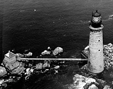
 US Coast Guard photo | |
 | |
| Location | Offshore of Boston, Massachusetts |
|---|---|
| Coordinates | 42°21′53.6″N 70°52′8.7″W / 42.364889°N 70.869083°W |
| Tower | |
| Constructed | 1903 |
| Foundation | Granite |
| Construction | Granite Block |
| Automated | 1976, solar 2001 |
| Height | 113 feet (34 m) (tower) |
| Shape | Conical |
| Markings | Natural with Black Lantern |
| Heritage | National Register of Historic Places listed place |
| Fog signal | HORN: 2 every 20s |
| Light | |
| First lit | 1905 |
| Focal height | 96 feet (29 m) |
| Lens | First order Fresnel Lens (original), VRB-25 (current) |
| Range | 15 nautical miles (28 km; 17 mi) |
| Characteristic | |
Graves Light Station | |
| Nearest city | Boston, Massachusetts |
| Architect | Royal Luther |
| Website | www |
| MPS | Lighthouses of Massachusetts TR |
| NRHP reference No. | 87002041[1] |
| Added to NRHP | September 28, 1987 |
The Graves Light is a lighthouse located on The Graves, the outermost island of the Boston Harbor Islands National Recreation Area, and 9 miles (14 km) offshore of downtown Boston, Massachusetts, USA.[2][3][4][5]
At 113 feet (34 m), it is the tallest lighthouse in the approaches to the Port of Boston, and is an important navigation aid for traffic to and from the port. It was built at the same time that the North Channel into Boston Harbor was dredged to become the principal entrance for large vessels. The Graves are the outermost rocks near the outer end of the North Channel.[2]
It was added to the National Register of Historic Places as Graves Light Station on September 28, 1987, reference number 87002041.
- ^ Cite error: The named reference
nriswas invoked but never defined (see the help page). - ^ a b Cite error: The named reference
chartwas invoked but never defined (see the help page). - ^ Cite error: The named reference
cghistwas invoked but never defined (see the help page). - ^ Cite error: The named reference
cgllwas invoked but never defined (see the help page). - ^ Cite error: The named reference
rowlettwas invoked but never defined (see the help page).