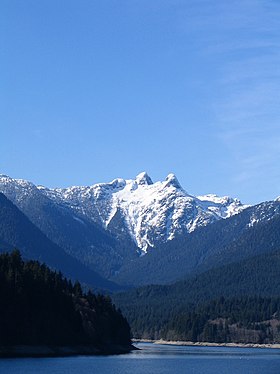
| West Lion | |
|---|---|
Location northwest of Vancouver | |
| Highest point | |
| Elevation | 1,654 m (5,427 ft) |
| Prominence | 369 m (1,211 ft) |
| Coordinates | 49°27′28″N 123°11′11″W / 49.45778°N 123.18639°W |
| Geography | |
| Location | British Columbia, Canada |
| Region | Metro Vancouver Regional District |
| District | New Westminster Land District |
| Parent range | Howe Sound Group |
| Topo map | NTS 92G6 North Vancouver |
| Climbing | |
| First ascent | 1889 H. Bell-Irving; Chief Joe Capilano; Squamish First Nation |
| Easiest route | class 3–4 scramble |
| East Lion | |
|---|---|
| Highest point | |
| Elevation | 1,606 m (5,269 ft) |
| Prominence | 121 m (397 ft) |
| Coordinates | 49°27′22″N 123°10′52″W / 49.45611°N 123.18111°W |
| Geography | |
| Location | British Columbia, Canada |
| District | New Westminster Land District |
| Parent range | Howe Sound Group |
| Topo map | NTS 92G/06 |
| Climbing | |
| First ascent | 1903 W. Latta; J. Latta; R. Latta |
| Easiest route | class 4 scramble |
The Lions, known as Ch'ích'iyúy Elx̱wíḵn ("The Twin Sisters") in the Sḵwx̱wú7mesh (Squamish) language, are a pair of pointed peaks (West Lion – 1,646 m (5,400 ft);[1] East Lion – 1,606 m (5,269 ft))[2] along the North Shore Mountains in Metro Vancouver, British Columbia, Canada. They can be seen from much of the Greater Vancouver area, as far as Robert Burnaby Park in East Burnaby, south to parts of Surrey, and from the west on the Howe Sound Islands and the Sunshine Coast. Along with the Lions Gate Bridge named in their honour, these twin summits have become one of the most recognizable Vancouver landmarks. The city's BC Lions CFL football team is also named in their honour. Lions Gate Entertainment which was founded in Vancouver in July, 1997 is also named for the peaks.
- ^ "West Lion". Bivouac.com.
- ^ "East Lion". Bivouac.com.

