| The Roaches | |
|---|---|
 | |
| Highest point | |
| Elevation | 505 m (1,657 ft) |
| Prominence | c. 120 m (394 ft) |
| Parent peak | Shining Tor |
| Listing | Dewey |
| Geography | |
 | |
| Location | Staffordshire, England |
| Parent range | Peak District |
| OS grid | SK001638 |
| Topo map | OS Landranger 119110 |
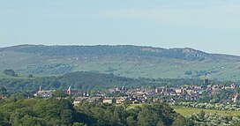
The Roaches (from the French les roches – the rocks) is a prominent rocky ridge above Leek and Tittesworth Reservoir in the Staffordshire Peak District of England. The ridge with its rock formations rises steeply to 505 m (1,657 ft).[1]
Along with Ramshaw Rocks and Hen Cloud, from Old English Henge Clud, meaning "steep rock", they form a gritstone escarpment, which is popular with hikers, rock climbers and freerunners. It is often very busy especially at weekends.
The Roaches Estate was purchased by the Peak District National Park Authority in the 1980s to safeguard the area from adverse development. From May 2013 Staffordshire Wildlife Trust took on the management of the Roaches Estate.
In clear conditions, it is possible to see much of Cheshire and views stretching as far as Snowdon in Wales and Winter Hill in Lancashire.
The Roaches are the most prominent part of a curving ridge which extends for several miles from Hen Cloud in the south to Back Forest and Hangingstone in the northwest. At the top there is a small pool called Doxey Pool that is, according to legend, inhabited by a water spirit. Nearby are the broad hills of Gun and Morridge.
- ^ Kent, Jeff, Staffordshire's 1,000-Foot Peaks, Witan Books, 2013, ISBN 978-0-9927505-0-3.