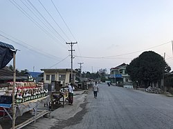
Theinni
‹See Tfd›သႅၼ်ဝီ Hsenwi | |
|---|---|
 | |
| Coordinates: 23°18′N 97°58′E / 23.300°N 97.967°E | |
| Country | |
| State | |
| District | Lashio District |
| Township | Hsenwi Township |
| Area | |
| • City | 3.92 sq mi (10.15 km2) |
| Population (2019)[1] | 9,392 |
| • Metro | 55,938 |
| • Ethnicities | |
| • Religions | Buddhism |
| Time zone | UTC+6.30 (MST) |
Theinni or Hsenwi (Shan: ‹See Tfd›သႅၼ်ဝီ; Burmese: သိန္နီ, pronounced [θèiɰ̃nì]; Thai: แสนหวี, RTGS: Saen Wi, pronounced [sɛ̌ːn wǐː]) is a town in northern Shan State of Burma, situated near the north bank of the Nam Tu River and now the centre of Hsenwi Township in Lashio District.[2] It is 28 miles (45 km) north of Lashio[3] and 2,100 feet (640 m) above sea level.[4]
After the disruption of the Dali Kingdom by Kublai Khan, Theinni seems to have been the centre of the independent Shan princely states, with various capitals in the Shweli River and Nam Tu River valleys. This kingdom of Kawsampi was ended by the Burmese in 1738 (or thereabouts), and the country was divided into various states with appointment orders from Ava. Numerous rebellions and civil wars reduced Theinni from its position as arguably the most powerful and populous Shan state to what is perceived as a condition of fearful desolation. It later regained much population since the British occupation in 1888, but is still far from its old prosperity. The ruins of what was the old capital of Hsenwi State lie at a short distance, and show it to have been a large and well-built town.[5]
It is de jure a part of Burma, but is currently controlled by the Brotherhood Alliance as of 30 October 2023 as a result of the 2021–2023 Myanmar civil war.[6]
- ^ Myanmar Information Management Unit (September 2019). Theinni Myone Daethasaingyarachatlatmya သိန္နီမြို့နယ် ဒေသဆိုင်ရာအချက်လက်များ [Hsenwi Township Regional Information] (PDF) (Report). MIMU. Retrieved 17 October 2023.
- ^ "Archived copy" (PDF). Archived from the original (PDF) on 2012-03-29. Retrieved 2011-06-22.
{{cite web}}: CS1 maint: archived copy as title (link) Map of Hseni Township - ^ "Welcome to MRTV-3". Archived from the original on 2011-09-29. Retrieved 2011-06-24.
- ^ "Archived copy" (PDF). Archived from the original (PDF) on 2011-10-02. Retrieved 2011-06-24.
{{cite web}}: CS1 maint: archived copy as title (link) Page 8 - ^ One or more of the preceding sentences incorporates text from a publication now in the public domain: Chisholm, Hugh, ed. (1911). "Theinni". Encyclopædia Britannica. Vol. 26 (11th ed.). Cambridge University Press. pp. 743–744.
- ^ Pan, Myat (2023-10-30). "Myanmar junta suffers heavy losses as Brotherhood Alliance captures dozens of bases". Myanmar Now. Retrieved 2023-10-30.
