| Theodore Wirth Park | |
|---|---|
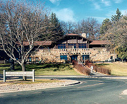
 Golf lodge at Theodore Wirth Park | |
 | |
| Type | Urban park |
| Location | |
| Coordinates | 44°59′24″N 93°19′23″W / 44.99°N 93.323°W |
| Area | 759 acres (307 ha) (3.07 km2) |
| Created | 1889 |
| Status | Open all year |
Theodore Wirth Park is the regional park managed by the Minneapolis Park and Recreation Board. The park land is shared by Minneapolis and the neighboring suburb of Golden Valley. Formally named Theodore Wirth Regional Park, it includes two golf courses (an 18-hole course and a 9-hole par 3 course), Wirth Lake, Birch Pond, cross-country ski trails, mountain biking trails, snow tubing hills, and other amenities. It forms a significant portion of the Grand Rounds Scenic Byway, linking the Chain of Lakes area with the Victory Memorial Parkway.