Thma Puok
ស្រុកថ្មពួក | |
|---|---|
 Part of the Banteay Chhmar site | |
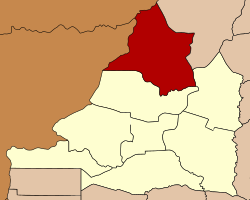
 Map showing the location of the district within Banteay Meanchey Province. | |
| Coordinates: 13°45′N 103°0′E / 13.750°N 103.000°E | |
| Country | |
| Province | Banteay Meanchey |
| Communes | 6 |
| Villages | 62 |
| Population (2008) | |
| • Total | 61,189 |
| Time zone | +7 |
| Geocode | 0107 |
Thma Puok (Khmer: ស្រុកថ្មពួក, lit. 'The Crumbled Stone') is a district (Srok) in the north of Banteay Meanchey province, in north-western Cambodia. The district capital is Thma Puok town located around 42 kilometres north of the provincial capital of Sisophon by road. The district shares a border with Thailand to the west and Oddar Meanchey province to the north east. No national highway runs through the district but national road 56 from Sisophon to Samraong in Oddar Meanchey province crosses the district from north to south. The district is home to the large temple complex of Banteay Chhmar. The temple was built in the late 12th or early 13th century by Jayavarman VII and is a modest tourist destination.[1]
The district is easily accessed by road from Sisophon (42 km), Battambang (city) (110 km), Siem Reap (city) (144 km) and Samraong (71 km). Thma Puok district is the largest districts in Banteay Meanchey province by land area but has a relatively small population due to its isolation. Large parts of the district, especially in the north west towards Thailand, are largely unpopulated. There is one official border crossing with Thailand in Kouk Romiet commune. One provincial road begins at the border and runs south east through the district to an intersection at Sarongk in Svay Chek district. Another provincial road runs north from Banteay Chmar commune on National Road 56 to Banteay Ampil district in Oddar Meanchey province. Numerous smaller roads also run to the Thai border in the north western part of the district.[2]
