Thompson, North Dakota | |
|---|---|
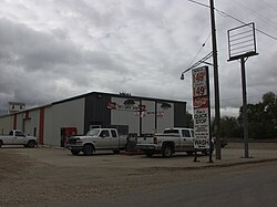
 S&T Quick Stop, the town's gas station and convenience store. | |
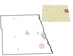
 Location of Thompson, North Dakota | |
| Coordinates: 47°46′31″N 97°06′19″W / 47.77528°N 97.10528°W | |
| Country | United States |
| State | North Dakota |
| County | Grand Forks |
| Metro | Greater Grand Forks |
| Founded | 1881 |
| Government | |
| • Mayor | Jeremy Hughes |
| Area | |
• Total | 0.47 sq mi (1.23 km2) |
| • Land | 0.47 sq mi (1.21 km2) |
| • Water | 0.01 sq mi (0.02 km2) |
| Elevation | 869 ft (265 m) |
| Population | |
• Total | 1,101 |
• Estimate (2022)[4] | 1,068 |
| • Density | 2,352.56/sq mi (909.26/km2) |
| Time zone | UTC-6 (Central (CST)) |
| • Summer (DST) | UTC-5 (CDT) |
| ZIP code | 58278 |
| Area code | 701 |
| FIPS code | 38-78660 |
| GNIS feature ID | 1036294[2] |
| Highways | ND 15 |
| Website | cityofthompsonnd.com |
Thompson is a city in Grand Forks County, North Dakota, United States. It is part of the "Grand Forks, ND-MN Metropolitan Statistical Area" or "Greater Grand Forks". It is located on the border of Allendale and Walle townships, with Walle on the east and Allendale on the west. The population was 1,101 at the 2020 census.[3] Thompson was founded in 1881.
- ^ "ArcGIS REST Services Directory". United States Census Bureau. Retrieved September 20, 2022.
- ^ a b U.S. Geological Survey Geographic Names Information System: Thompson, North Dakota
- ^ a b "Explore Census Data". United States Census Bureau. Retrieved October 11, 2023.
- ^ Cite error: The named reference
USCensusEst2022was invoked but never defined (see the help page).