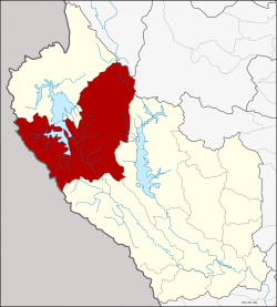
Thong Pha Phum
ทองผาภูมิ | |
|---|---|
 | |
 District location in Kanchanaburi province | |
| Coordinates: 14°44′45″N 98°37′30″E / 14.74583°N 98.62500°E | |
| Country | Thailand |
| Province | Kanchanaburi |
| Seat | Tha Khanun |
| Area | |
• Total | 3,655.171 km2 (1,411.269 sq mi) |
| Population (2014)[1] | |
• Total | 56,119 |
| • Density | 15/km2 (40/sq mi) |
| Time zone | UTC+7 (ICT) |
| Postal code | 71180 |
| Geocode | 7107 |
Thong Pha Phum (Thai: ทองผาภูมิ, pronounced [tʰɔ̄ːŋ pʰǎː pʰūːm]) is a district (amphoe) in the northern part of Kanchanaburi province, central Thailand.