This article relies largely or entirely on a single source. (April 2013) |
Three Countries Bridge
| |
|---|---|
 The Three Countries Bridge | |
| Coordinates | 47°35′29.5″N 7°35′24″E / 47.591528°N 7.59000°E |
| Crosses | Rhine |
| Locale | Huningue, France / Weil-am-Rhein, Germany; near Basel (Basle), Switzerland |
| Characteristics | |
| Total length | 248 metres (814 ft) |
| Width | 5.5 metres (18 ft) |
| Height | 24.75 metres (81.2 ft) |
| Longest span | 229.4 metres (753 ft) |
| Clearance above | 7.8 metres (26 ft) |
| History | |
| Architect | Dietmar Feichtinger |
| Engineering design by | Leonhardt, Andrä und Partner |
| Construction start | 2006 |
| Construction end | 2007 |
| Construction cost | €10,000,000 (approximate) |
| Opened | 2007 |
| Inaugurated | 30 June 2007 |
| Statistics | |
| Daily traffic | Cyclists and pedestrians |
| Location | |
 | |
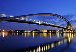
The Three Countries Bridge (German: Dreiländerbrücke, French: La passerelle des Trois Pays) is an arch bridge which crosses the Rhine between the commune of Huningue (France) and Weil am Rhein (Germany), within the Basel (Switzerland) metropolitan area. It is the world's longest single-span bridge dedicated exclusively to carrying pedestrians and cyclists.[α] Its overall length is 248 metres (813 ft 8 in) and its main span is 229.4 metres (752 ft 7 in).[1]
Its name comes from the bridge's location between France, Germany and Switzerland (which is about 200 metres (660 ft) distant). It was designed by the Franco-Austrian architect Dietmar Feichtinger.
Cite error: There are <ref group=lower-greek> tags on this page, but the references will not show without a {{reflist|group=lower-greek}} template (see the help page).
- ^ "Une passerelle entre deux rives et trois pays" (in French). Batiactu. Archived from the original on 2007-09-27. Retrieved 2013-04-02.