Thurrock
Borough of Thurrock | |
|---|---|
 Grays town skyline | |
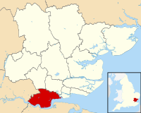
 Shown within Essex | |
| Coordinates: 51°30′00″N 0°25′00″E / 51.50000°N 0.41667°E | |
| Country | United Kingdom |
| Constituent country | England |
| Region | East |
| Ceremonial county | Essex |
| Admin HQ | Grays |
| Government | |
| • Body | Thurrock Council (Labour) |
| • MPs | Jen Craft (Labour) James McMurdock (Reform) |
| Area | |
| • Total | 163.38 km2 (63.08 sq mi) |
| Population | |
| • Total | Ranked 118th 176,877 |
| • Density | 1,080/km2 (2,800/sq mi) |
| Ethnicity (2021) | |
| • Ethnic groups | |
| Religion (2021) | |
| • Religion | List
|
| Time zone | GMT |
| • Summer (DST) | British Summer Time |
| ISO 3166 code | GB-THR |
| ONS code | 00KG (ONS) E06000034 (GSS) |
| Website | thurrock |
Thurrock (/ˈθʌrək/) is a unitary authority area with borough status in the ceremonial county of Essex, England. It lies on the north bank of the River Thames immediately east of London and has over 18 miles (29 km) of riverfront including the Port of Tilbury, the principal port for London. Thurrock is within the London commuter belt and is an area of regeneration within the Thames Gateway redevelopment zone. The borough includes the northern ends of the Dartford Crossing.
The local authority is Thurrock Council, based in Grays. The borough also includes Purfleet-on-Thames, South Ockendon, Stanford-le-Hope and Tilbury, as well as other villages and surrounding areas. More than half of the borough is designated as Green Belt.
The neighbouring districts are the London Borough of Havering, Brentwood, Basildon and Castle Point. On the opposite side of the Thames are Gravesham and Dartford in Kent.
- ^ a b UK Census (2021). "2021 Census Area Profile – Thurrock Local Authority (E06000034)". Nomis. Office for National Statistics. Retrieved 5 January 2024.