 Satellite image of the island (northeast-up oriented) | |
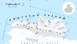
 Map of Thurston Island | |
| Geography | |
|---|---|
| Location | Antarctica |
| Coordinates | 72°6′S 99°0′W / 72.100°S 99.000°W |
| Area | 15,700 km2 (6,100 sq mi) |
| Area rank | 56th |
| Length | 215 km (133.6 mi) |
| Width | 90 km (56 mi) |
| Highest elevation | 750 m (2460 ft) |
| Highest point | Mount Howell |
| Administration | |
| Administered under the Antarctic Treaty System | |
Thurston Island (72°6′S 99°0′W / 72.100°S 99.000°W) is a largely ice-covered, glacially dissected island, 135 nautical miles (250 km; 155 mi) long and 55 nautical miles (102 km; 63 mi) wide, lying between Amundsen Sea and Bellingshausen Sea a short way off the northwest end of Ellsworth Land, Antarctica. The island is separated from the mainland by Peacock Sound, which is occupied by the west portion of Abbot Ice Shelf.[1]
- ^ Alberts 1995, p. 746.
