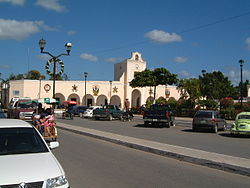
Ticul de Morales | |
|---|---|
 Ticul City Hall | |
 Region 7 Sur #089 | |
| Coordinates: 20°24′N 89°32′W / 20.400°N 89.533°W | |
| Country | |
| State | |
| Government | |
| • Type | PAN 2018–2021[1] |
| • Municipal President | Camilo Moises Salomon Lopez [2] |
| Area | |
• Total | 355.12 km2 (137.11 sq mi) |
| [2] | |
| Population (2010[3]) | |
• Total | 37,685 |
| Time zone | UTC-6 (Central Standard Time) |
| • Summer (DST) | UTC-5 (Central Daylight Time) |
| Postal Code | 97860 |
| Area code | 997 |
| INEGI Code | 089 |
| Major Airport | Merida (Manuel Crescencio Rejón) International Airport |
| IATA Code | MID |
| ICAO Code | MMMD |
Ticul de Morales Municipality is a municipality in the Mexican state of Yucatán. It is located in the western part of the state at (20°24′N 89°32′W / 20.400°N 89.533°W) 100 km south of the state capital city of Mérida. The municipality, which has an area of 355.12 km2 (137.11 sq mi), in the 2005 census reported 25,621 inhabitants. The city of Ticul which is the municipal seat had a population of 21,147, the ninth-largest community in the state in population. The majority are ethnically Maya. Its largest other towns are Pustunich and Yotholín.
- ^ "Presidente Municipal" (in Spanish). Mérida, Mexico: PRI. 2012. Retrieved 6 August 2015.
- ^ a b "Municipios de Yucatán »Santa Elena" (in Spanish). Retrieved 13 November 2018.
- ^ "Mexico In Figures:Sacalum, Yucatán". INEGI (in Spanish and English). Aguascalientes, México: Instituto Nacional de Estadística y Geografía (INEGI). Archived from the original on 6 May 2015. Retrieved 3 August 2015.
