Tierra Amarilla, New Mexico | |
|---|---|
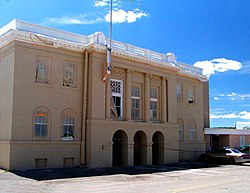
 Rio Arriba County Courthouse, Isaac Rapp, 1916-17 | |
Location within the state of New Mexico | |
| Coordinates: 36°42′22″N 106°33′35″W / 36.70611°N 106.55972°W[1] | |
| Country | United States |
| State | New Mexico |
| County | Rio Arriba |
| Area | |
• Total | 2.69 sq mi (6.98 km2) |
| • Land | 2.69 sq mi (6.96 km2) |
| • Water | 0.01 sq mi (0.01 km2) |
| Elevation | 7,487 ft (2,282 m) |
| Population | |
• Total | 297 |
| • Density | 110.49/sq mi (42.65/km2) |
| Time zone | UTC−7 (MST) |
| • Summer (DST) | UTC−6 (MDT) |
| ZIP code | 87575 |
| Area code | 575 |
| FIPS code | 35-77670 |
| GNIS feature ID | 2584225[1] |
| Website | www |
Tierra Amarilla is a census-designated place in and the county seat of Rio Arriba County, New Mexico, United States.[1][4]
Tierra Amarilla is Spanish for "Yellow Earth". The name refers to clay deposits found in the Chama River Valley and used by Native American peoples.[5]: 352–353 [6] Tewa and Navajo toponyms for the area also refer to the yellow clay.[5]: 352–353
- ^ a b c d U.S. Geological Survey Geographic Names Information System: Tierra Amarilla, New Mexico
- ^ "ArcGIS REST Services Directory". United States Census Bureau. Retrieved October 12, 2022.
- ^ Cite error: The named reference
USCensusDecennial2020CenPopScriptOnlywas invoked but never defined (see the help page). - ^ "Find a County". National Association of Counties. Retrieved June 7, 2011.
- ^ a b Cite error: The named reference
Toponymwas invoked but never defined (see the help page). - ^ Cite error: The named reference
roadsidewas invoked but never defined (see the help page).

