Tierra Amarilla Land Grant, New Mexico, Colorado | |
|---|---|
Location within the state of New Mexico | |
| Coordinates: 36°42′01″N 106°32′59″W / 36.70028°N 106.54972°W[1] | |
| Country | United States |
| Area | |
| • Total | 929 sq mi (2,410 km2) |


The Tierra Amarilla Land Grant in northern New Mexico and southern Colorado consists of 594,516 acres (2,405.92 km2) (929 sq miles)[2] of mountainous land. The government of New Mexico awarded it to Manuel Martinez and his offspring in 1832. The grant was settled by Hispanics in the 1860s and the original inhabitants, the Ute Indians, were induced to leave. Settlers were given small plots, but most of the land in the grant area was designated as common land for the use of all the settlers and their descendants. After its conquest of New Mexico in 1846, the United States government upheld the validity of the grant, but subsequent actions by the U.S. did not protect the right to access common lands by the settlers. Politician and land speculator Thomas Catron, a member of the Santa Fe Ring, acquired nearly all the land by 1883 but later sold it to a development company. Access to the common lands of the grant by the Hispanic settlers and their descendants gradually disappeared as the common land became owned by Anglo ranchers, development companies, and speculators.
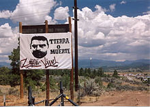
Legal disputes and protests, some with violence, between the descendants of the Hispanic settlers and speculators, ranchers, and developers about ownership of and access to land in the grant area were frequent and continued for more than 100 years. The best known incident was the 1967 occupation of the Rio Arriba county courthouse by Hispanic protesters asserting that grant land should be owned by descendants of the original settlers. Later, the Jicarilla Apache whose reservation borders the grant began purchasing land and in the 21st century became the largest landowner in the grant.
Scholar David Correia summed up a century of land grant controversies. The heirs and activists attempting to retain common lands for common usage as originally conceived in the land grants were "trapped in a legal system [of the United States] incapable of understanding common property."[3]
- ^ Geographic Names Information System (GNIS) details for Tierra Amarilla, New Mexico; United States Geological Survey (USGS); November 13, 1980.
- ^ "Treaty of Guadalupe Hidalgo" (PDF). General Accounting Office. U.S. government. Retrieved November 10, 2023.
- ^ Correia, David. "Who is Reies Lopez Tijerina? A Reappraisal of a Folk Hero". Alibi.com. Retrieved November 16, 2023.

