This article needs additional citations for verification. (December 2008) |
Tierra del Fuego Province
Provincia de Tierra del Fuego | |
|---|---|
 Porvenir | |
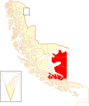
 Location in the Magallanes Region | |
| Coordinates: 53°36′S 69°23′W / 53.600°S 69.383°W | |
| Country | |
| Region | |
| Capital | Porvenir |
| Communes | Porvenir Primavera Timaukel |
| Government | |
| • Type | Provincial |
| • Presidential provincial delegate | Karim Fierro Brstilo |
| Area | |
• Total | 22,592.7 km2 (8,723.1 sq mi) |
| Population (2012 Census)[1] | |
• Total | 6,656 |
| • Density | 0.29/km2 (0.76/sq mi) |
| • Urban | 4,734 |
| • Rural | 2,170 |
| Sex | |
| • Men | 4,418 |
| • Women | 2,486 |
| Time zone | UTC-3 (CLST[2]) |
| • Summer (DST) | UTC-3 (CLST[3]) |
| Area code | 56 + 61 |
| Website | Government of Tierra del Fuego |
Tierra del Fuego Province (Spanish: Provincia de Tierra del Fuego) is one of four provinces in the southern Chilean region of Magallanes and Antártica Chilena (XII). It includes the Chilean or western part of the main island of Tierra del Fuego, except for the part south of the Cordillera Darwin, which is in Antártica Chilena Province.
Chilean Tierra del Fuego has two towns, Porvenir, capital of the province, and Cerro Sombrero, and a number of small villages. A key geographical feature is Bahía Inútil ("Useless Bay"), so named by British geographers in the late 19th century because the bay is not useful as a port.[4]
- ^ a b c "Territorial division of Chile" (PDF) (in Spanish). National Statistics Institute. 2007. Retrieved 18 March 2011.
- ^ "Chile Time". WorldTimeZones.org. Archived from the original on 2010-07-13. Retrieved 2010-07-28.
- ^ "Chile Summer Time". WorldTimeZones.org. Archived from the original on 2007-09-11. Retrieved 2010-07-28.
- ^ King, P.P. (1839). Voyages of the Adventure and Beagle. p. 125.

