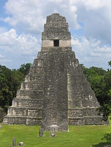
 Temple I viewed across the main plaza from Temple II | |
| Alternative name | El Gran Jaguar, Temple of Ah Cacao |
|---|---|
| Location | Guatemala |
| Coordinates | 17°13′19″N 89°37′22″W / 17.221944°N 89.622778°W |
| Height | 47 m |
| History | |
| Builder | Jasaw Chan Kʼawiil I (other names) Ah Cacao, King Moon Double Comb |
| Material | local limestone |
| Founded | c. 732 AD |
| Abandoned | c. 1450 |
| Periods | Classic-Postclassic |
| Cultures | Mayan |
| Site notes | |
| Excavation dates | 1955–1964 |
| Archaeologists | Aubrey Trik; George Guillemin |
| Condition | stabilized ruin |
| Public access | Yes |
Tikal Temple I is the designation given to one of the major structures at Tikal, one of the largest cities and archaeological sites of the pre-Columbian Maya civilization in Mesoamerica. It is located in the Petén Basin region of northern Guatemala. It also is known as the Temple of the Great Jaguar because of a lintel that represents a king sitting upon a jaguar throne.[1] An alternative name is the Temple of Ah Cacao, after the ruler buried in the temple.[nb 1] Temple I is a typically Petén-styled limestone stepped pyramid structure that is dated to approximately 732 AD.
Situated at the heart of a World Heritage Site, the temple is surmounted by a characteristic roof comb, a distinctive Maya architectural feature. Building Temple I on the eastern side of the Great Plaza was a significant deviation from the established tradition of building funerary temples just north of the plaza in Tikal's North Acropolis.[2][3]
Cite error: There are <ref group=nb> tags on this page, but the references will not show without a {{reflist|group=nb}} template (see the help page).
