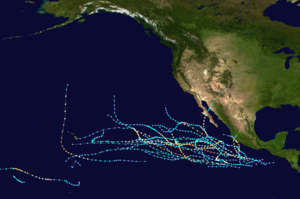
| Timeline of the 1992 Pacific hurricane season | |||||
|---|---|---|---|---|---|
 Season summary map | |||||
| Season boundaries | |||||
| First system formed | January 28, 1992 | ||||
| Last system dissipated | November 23, 1992 | ||||
| Strongest system | |||||
| Name | Tina | ||||
| Maximum winds | 150 mph (240 km/h) (1-minute sustained) | ||||
| Lowest pressure | 932 mbar (hPa; 27.52 inHg) | ||||
| Longest lasting system | |||||
| Name | Tina | ||||
| Duration | 24 days | ||||
| |||||
The 1992 Pacific hurricane season was the most active season on record, featuring 27 named storms. The season officially started on May 15, in the Eastern Pacific—designated as the area east of 140°W—and on June 1, in the Central Pacific, which is between the International Date Line and 140°W. The season officially ended in both basins on November 30. These dates typically limit the period of each year when most tropical cyclones form in the eastern Pacific basin. Lasting 24 days, Hurricane Tina became the longest lived North Pacific tropical cyclone on record. Its longevity broke the old record for the Eastern and Central Pacific of 20 days, set by Hurricane Fico in 1978; and the old record for the Western Pacific of 22 days, set by Typhoon Rita in 1972.[1]
This timeline documents all the storm formations, strengthening, weakening, landfalls, extratropical transitions, as well as dissipation. The timeline includes information that was not operationally released, meaning that information from post-storm reviews by the National Hurricane Center, such as information on a storm that was not operationally warned on, have been included.
The graphical bar below gives a brief overview of storm activity during the season, and for convenience, the storm's maximum intensity is included as a color bar.
- ^ "Hurricane Tina Tropical Cyclone Report". National Hurricane Center. 1993. Retrieved May 8, 2010.