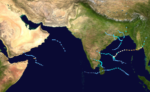
| Timeline of the 2008 North Indian Ocean cyclone season | |||||
|---|---|---|---|---|---|
 Season summary map | |||||
| Season boundaries | |||||
| First system formed | April 27, 2008 | ||||
| Last system dissipated | December 8, 2008 | ||||
| Strongest system | |||||
| Name | Nargis | ||||
| Maximum winds | 165 km/h (105 mph) (3-minute sustained) | ||||
| Lowest pressure | 962 hPa (mbar) | ||||
| Longest lasting system | |||||
| Name | Nargis | ||||
| Duration | 7 days | ||||
| |||||
The 2008 North Indian Ocean cyclone season officially ran throughout the year during 2008, with the first depression forming on April 27. The timeline includes information that was not operationally released, meaning that information from post-storm reviews by the Joint Typhoon Warning Center (JTWC), and the India Meteorological Department (IMD), such as information on a storm that was not operationally warned on. This timeline documents all the storm formations, strengthening, weakening, landfalls, extratropical transitions, as well as dissipation's during the 2008 North Indian Ocean cyclone season.
During the year, 10 tropical depressions, 4 Cyclonic storms and 1 Severe Cyclonic storm formed. The scope of this basin is north of the Equator and west of the Malaysian Peninsula. The India Meteorological Department (IMD) and Joint Typhoon Warning Center (JTWC) monitor tropical cyclones in this basin. This basin is divided into two different seas by the IMD; the Arabian Sea to the west of India, which is abbreviated as ARB by the IMD, and the Bay of Bengal to the east of India, which is abbreviated as BOB by the IMD.