| Timeline of the 2013 North Indian Ocean cyclone season | |||||
|---|---|---|---|---|---|
 Season summary map | |||||
| Season boundaries | |||||
| First system formed | May 10, 2013 | ||||
| Last system dissipated | December 13, 2013 | ||||
| Strongest system | |||||
| Name | Phailin | ||||
| Maximum winds | 215 km/h (130 mph) (1-minute sustained) | ||||
| Lowest pressure | 940 hPa (mbar) | ||||
| Longest lasting system | |||||
| Name | Madi | ||||
| Duration | 6.125 days | ||||
| |||||
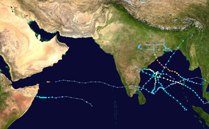
The 2013 North Indian Ocean cyclone season was an average season during the period of tropical cyclone formation in the North Indian Ocean.[a] The season began in May with the formation of Cyclone Viyaru, which made landfall on Bangladesh, destroying more than 26,500 houses.[b][2] After a period of inactivity, Cyclone Phailin formed in October, and became an extremely severe cyclonic storm. Additionally, it was a Category 5-equivalent cyclone on the Saffir–Simpson hurricane wind scale. It then made landfall in the Indian states of Andhra Pradesh and Odisha, becoming the most intense cyclone to strike the country since the 1999 Odisha cyclone.[3] In November, cyclones Helen and Lehar formed, and they both made landfall in Andhra Pradesh just one week away from each other.[4] The latter also affected the Andaman and Nicobar Islands.[4]
This timeline documents all the events of this season, including the strengthening, weakening, formation, dissipation, and landfall of tropical cyclones in both the Bay of Bengal and the Arabian Sea. When depressions form in the Bay of Bengal, they receive the prefix BOB by the India Meteorological Department (IMD). Likewise, depressions which form in the Arabian Sea are designated the prefix ARB, and those which form over land are given the prefix LAND. The Joint Typhoon Warning Center (JTWC) also creates advisories on storms in the North Indian Ocean. It designates the prefix B for storms that form in the Bay of Bengal, and the prefix A for those which form in the Arabian Sea. Best track data from the IMD and JTWC is utilized in this article, which means that post-storm analyses take precedence over operational advisories and the like. Meteorologists use one time zone, Coordinated Universal Time (UTC), when issuing forecasts and advisories.[5] As such, the time of the events in this season are listed in UTC as well as the local time, which is, in this case, Indian Standard Time (IST).
- ^ "Tropical Cyclones". India Meteorological Department. Archived from the original on 2009-05-29. Retrieved March 31, 2021.
- ^ "Tropical Cyclone Mahasen - May 2013". ReliefWeb. Retrieved 2021-05-06.
- ^ Cite error: The named reference
:4was invoked but never defined (see the help page). - ^ a b "A week after Helen,Andhra braces for 'very severe cyclonic storm' Lehar". The Indian Express. 2013-11-26. Retrieved 2021-04-07.
- ^ "Understanding the Date/Time Stamps". Miami, Florida: NOAA National Hurricane Center. Archived from the original on July 10, 2020. Retrieved July 10, 2020.
Cite error: There are <ref group=lower-alpha> tags or {{efn}} templates on this page, but the references will not show without a {{reflist|group=lower-alpha}} template or {{notelist}} template (see the help page).