| Timeline of the 2014 Atlantic hurricane season | |||||
|---|---|---|---|---|---|
 Season summary map | |||||
| Season boundaries | |||||
| First system formed | July 1, 2014 | ||||
| Last system dissipated | October 28, 2014 | ||||
| Strongest system | |||||
| Name | Gonzalo | ||||
| Maximum winds | 145 mph (230 km/h) (1-minute sustained) | ||||
| Lowest pressure | 940 mbar (hPa; 27.76 inHg) | ||||
| Longest lasting system | |||||
| Name | Edouard | ||||
| Duration | 8 days | ||||
| |||||
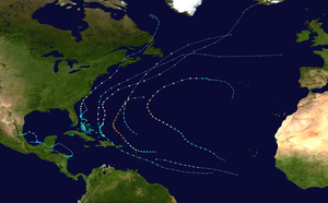
The 2014 Atlantic hurricane season was an event in the annual hurricane season in the north Atlantic Ocean. It featured below-average tropical cyclone activity,[nb 1] with the fewest named storms since the 1997 season.[2] The season officially began on June 1, 2014 and ended on November 30, 2014. These dates, adopted by convention, historically describe the period in each year when most tropical systems form.[3] Even so, there were no named storms during either the opening or closing months of the season, as the first, Hurricane Arthur, developed on July 1, and the last, Tropical Storm Hanna, dissipated on October 28.
Altogether, eight tropical storms formed during the season, including six hurricanes of which two intensified into major hurricanes.[nb 2] There was also one tropical depression that failed to reach tropical storm strength. Impact throughout the year was widespread. Arthur, which made landfall near Cape Lookout, North Carolina on July 3, with 100 mph (155 km/h) winds, was the strongest hurricane to strike the U.S. mainland since Hurricane Ike in 2008 (with 110 mph (175 km/h) winds).[2] The deadliest Atlantic storm of the season, Cristobal, barely touched land at all as it moved from Puerto Rico to Iceland in late August. Even so, it was responsible for at least seven fatalities: four on Hispaniola, one on Providenciales, and two along the U.S. East Coast.[2] In October, Bermuda was struck twice, as hurricanes Fay and Gonzalo made landfall only six days apart (October 12 and 18 respectively), leaving much damage in their wakes.[2]
This timeline documents tropical cyclone formations, strengthening, weakening, landfalls, extratropical transitions, and dissipations during the season. It includes information that was not released throughout the season, meaning that data from post-storm reviews by the National Hurricane Center, such as a storm that was not initially warned upon, has been included.
By convention, meteorologists use one time zone when issuing forecasts and making observations: Coordinated Universal Time (UTC), and also use the 24-hour clock (where 00:00 = midnight UTC).[5] The National Hurricane Center uses both UTC and the time zone where the center of the tropical cyclone is currently located. The time zones utilized (east to west) prior to 2020 were: Atlantic, Eastern, and Central.[6] In this timeline, all information is listed by UTC first with the respective regional time included in parentheses. Additionally, figures for maximum sustained winds and position estimates are rounded to the nearest 5 units (knots, miles, or kilometers), following the convention used in the National Hurricane Center's products. Direct wind observations are rounded to the nearest whole number. Atmospheric pressures are listed to the nearest millibar and nearest hundredth of an inch of mercury.
- ^ "Background Information: North Atlantic Hurricane Season". College Park, Maryland: NOAA Climate Prediction Center. Retrieved July 14, 2020.
- ^ a b c d Wiltgen, Nick (December 1, 2014). "2014 Hurricane Season in Review: Eight Things We'll Remember". weather.com. The Weather Channel. Retrieved July 21, 2020.
- ^ Dorst, Neal (June 1, 2018). "Hurricane Season Information". Frequently Asked Questions About Hurricanes. Miami, Florida: NOAA Atlantic Oceanographic and Meteorological Laboratory. Retrieved June 29, 2020.
- ^ "Saffir-Simpson Hurricane Wind Scale". Miami, Florida: National Hurricane Center. Retrieved June 29, 2020.
- ^ "Understanding the Date/Time Stamps". Miami, Florida: NOAA National Hurricane Center. Retrieved July 10, 2020.
- ^ "Update on National Hurricane Center Products and Services for 2020" (PDF). Miami, Florida: National Hurricane Center. April 20, 2020. Retrieved May 17, 2020.
Cite error: There are <ref group=nb> tags on this page, but the references will not show without a {{reflist|group=nb}} template (see the help page).