| Tinajas Altas Mountains | |
|---|---|
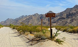
 Sign along El Camino Del Diablo in Barry M. Goldwater Air Force Range, near Wellton, Arizona, at spur road to Tinajas Altas. | |
| Highest point | |
| Peak | Unnamed, 32°16′26″N 114°02′48″W / 32.27389°N 114.04667°W |
| Elevation | 843 m (2,766 ft) |
| Dimensions | |
| Length | 35 km (22 mi) |
| Width | 6.4 km (4.0 mi) |
| Geography | |
| Countries | United States and Mexico |
| State | Arizona |
| Regions | Sonoran Desert, Yuma Desert and Gran Desierto de Altar |
| District | Yuma County, Arizona |
| Settlement | Fortuna Foothills, Arizona |
| Range coordinates | 32°17′00″N 114°03′00″W / 32.2833333°N 114.05°W |
| Borders on | Gila Mountains (Yuma County), Yuma Desert, Lechuguilla Desert and Gran Desierto de Altar |
| Geology | |
| Rock type | granite–(light-colored) |
The Tinajas Altas Mountains (O'odham: Uʼuva:k or Uʼuv Oopad) are an extremely arid northwest–southeast trending mountain range in southern Yuma County, Arizona, approximately 35 mi southeast of Yuma, Arizona. The southern end of the range extends approximately one mile into the northwestern Mexican state of Sonora on the northern perimeter of the Gran Desierto de Altar. The range is about 22 mi in length and about 4 mi wide at its widest point. The highpoint of the range is unnamed and is 2,766 feet (843 meters) above sea level and is located at 32°16'26"N, 114°02'48"W (NAD 1983 datum). Aside from the portion of the range in Mexico, the entirety of the range lies within the Barry M. Goldwater Air Force Range. They lie at the heart of the traditional homeland of the Hia C-eḍ O'odham people.
