Tinmouth, Vermont | |
|---|---|
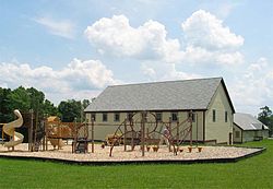
 Community center and elementary school in Tinmouth | |
 Tinmouth, Vermont | |
| Coordinates: 43°26′54″N 73°3′3″W / 43.44833°N 73.05083°W | |
| Country | United States |
| State | Vermont |
| County | Rutland |
| Chartered | 1761[1][2] |
| Communities |
|
| Area | |
| • Total | 28.4 sq mi (73.6 km2) |
| • Land | 28.3 sq mi (73.3 km2) |
| • Water | 0.1 sq mi (0.3 km2) |
| Elevation | 1,371 ft (418 m) |
| Population (2020) | |
| • Total | 553 |
| • Density | 19/sq mi (7.5/km2) |
| Time zone | UTC-5 (Eastern (EST)) |
| • Summer (DST) | UTC-4 (EDT) |
| ZIP code | 05773, 05777, 05757, 05774, 05739, 05761 |
| Area code | 802 |
| FIPS code | 50-72925[3] |
| GNIS feature ID | 1462227[4] |
| Website | https://tinmouthvt.gov/ |
43°26′54″N 73°3′3″W / 43.44833°N 73.05083°W Tinmouth is a town in Rutland County, Vermont, United States. The population was 553 at the 2020 census.[5]
- ^ "Tinmouth". Vermont Center for Geographic Information. Retrieved April 4, 2009.
- ^ "A Town in Transition". Vermont Life. Spring 2008. Retrieved April 4, 2009.
- ^ "U.S. Census website". United States Census Bureau. Retrieved January 31, 2008.
- ^ "US Board on Geographic Names". United States Geological Survey. October 25, 2007. Retrieved January 31, 2008.
- ^ "Census - Geography Profile: Tinmouth town, Rutland County, Vermont". United States Census Bureau. Retrieved January 6, 2022.