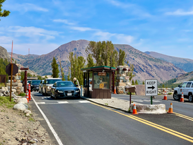
| Tioga Pass | |
|---|---|
 | |
| Elevation | 9,945 ft (3,031 m)[1] |
| Traversed by | |
| Location | Mono / Tuolumne counties, California, United States |
| Range | Sierra Nevada |
| Coordinates | 37°54′40″N 119°15′29″W / 37.91111°N 119.25806°W[1] |
| Topo map | USGS Tioga Pass |
Location in California | |
Tioga Pass is a mountain pass in the Sierra Nevada mountain range of California. State Route 120 runs through it, and serves as the eastern entry point for Yosemite National Park, at the Tioga Pass Entrance Station. It is the highest elevation highway pass in California and in the Sierra Nevada at an elevation of 9,945 ft (3,031 m).[1][2] Mount Dana is to the east of the pass, and Gaylor Peak to the west.
- ^ a b c U.S. Geological Survey Geographic Names Information System: Tioga Pass
- ^ "Tioga Pass in California". AllTrips. Retrieved 2012-04-21.
