Tipton County | |
|---|---|
 | |
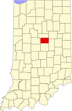
 Location within the U.S. state of Indiana | |
 Indiana's location within the U.S. | |
| Coordinates: 40°19′N 86°03′W / 40.31°N 86.05°W | |
| Country | |
| State | |
| Founded | January 15, 1844 |
| Named for | John Tipton |
| Seat | Tipton |
| Largest city | Tipton |
| Area | |
• Total | 260.57 sq mi (674.9 km2) |
| • Land | 260.54 sq mi (674.8 km2) |
| • Water | 0.03 sq mi (0.08 km2) 0.01% |
| Population (2020) | |
• Total | 15,359 |
| • Density | 59/sq mi (23/km2) |
| Time zone | UTC−5 (Eastern) |
| • Summer (DST) | UTC−4 (EDT) |
| Congressional district | 5th |
| Indiana county number 80 FIPS Code 159 | |
Tipton County is a county in the U.S. state of Indiana, located north of the state capital of Indianapolis. According to the 2020 census, it had a population of 15,359.[1] Its county seat is Tipton.[2] The county has four incorporated towns with a total population of about 7,000,[3] as well as many small unincorporated communities. It is divided into six townships which provide local services.[4][5] Three Indiana state roads and one U.S. Route cross the county,[6] as do two railroad lines.[7] Before the arrival of non-indigenous settlers in the early 19th century, the area was inhabited by several Native American tribes. The county was officially established in 1844, one of the last Indiana counties to be settled. Tipton and Howard Counties were established by the same legislative action on January 15.
- ^ "Tipton County, Indiana". United States Census Bureau. Retrieved June 7, 2023.
- ^ "Find a County – Tipton County IN". National Association of Counties. Archived from the original on February 3, 2012. Retrieved November 15, 2011.
- ^ "Tipton County, Indiana – County Subdivision and Place. GCT-PH1. Population, Housing Units, Area, and Density: 2000". US Census Bureau. Archived from the original on February 16, 2020. Retrieved February 9, 2011.
- ^ "Tipton". Indiana Township Association. Archived from the original on April 15, 2012. Retrieved November 15, 2011.
- ^ "Duties". United Township Association of Indiana. Retrieved January 6, 2011.
- ^ "Indiana Transportation Map 2009–2010" (PDF). Indiana Department of Transportation. 2009. Archived (PDF) from the original on November 18, 2009. Retrieved December 16, 2010.
- ^ "State of Indiana 2011 Rail System Map" (PDF). Indiana Department of Transportation. 2011. Archived (PDF) from the original on January 15, 2011. Retrieved June 19, 2011.