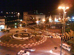
Tira
| |
|---|---|
| Hebrew transcription(s) | |
| • ISO 259 | Ṭira |
| • Also spelled | Tire (official) |
 | |
| Coordinates: 32°13′56″N 34°56′54″E / 32.23222°N 34.94833°E | |
| Grid position | 145/182 PAL |
| Country | |
| District | Central |
| Government | |
| • Mayor | Mamoun Abd al-Hay |
| Area | |
| • Total | 11,894 dunams (11.894 km2 or 4.592 sq mi) |
| Population (2022)[1] | |
| • Total | 27,802 |
| • Density | 2,300/km2 (6,100/sq mi) |
| Name meaning | The High Land |

Tira (Arabic: الطـّيرة, al-Tira, Hebrew: טִירָה, Ṭīra, lit. "Fort";[2]) is an Arab city in the Central District of Israel. Part of the Triangle, a concentration of Arab towns and villages adjacent to the Green Line, Tira is close to Kfar Saba. It is known for its weekly market and Arab cuisine.
Tira is not documented in 16th-century records, but its origins date back earlier. In the 18th century, it was resettled by Bani Sa'b tribesmen from Hajjah and Baqa. Today, its population has diverse origins.[3]
Located within Israel's fertile bread basket,[4] by 1976 Tira was estimated to have had up to two-thirds of its land expropriated by the state.[5] Today youth employment prospects are low, which has contributed to the city's high crime rate.[6] In 2022, the city had a population of 27,802.[1]
- ^ a b "Regional Statistics". Israel Central Bureau of Statistics. Retrieved 21 March 2024.
- ^ Palmer, 1881, p.194
- ^ Grossman, D. (1986). "Oscillations in the Rural Settlement of Samaria and Judaea in the Ottoman Period". in Shomron studies. Dar, S., Safrai, S., (eds). Tel Aviv: Hakibbutz Hameuchad Publishing House. p. 373
- ^ Abu Rass 1997, p. 219.
- ^ Jiryis 1976, p. 292.
- ^ Breiner 2021.


