This article possibly contains original research. (May 2019) |
Thirukovilur
Thirukoilure Thirukkovalur Tirukkoyilur | |
|---|---|
Municipality Administration | |
 | |
| Nickname(s): Koval, Temple City | |
| Coordinates: 11°58′03″N 79°12′20″E / 11.96750°N 79.20556°E | |
| Country | |
| State | Tamil Nadu |
| District | Kallakurichi district |
| Named for | Temples And Heritage Town |
| Government | |
| • Type | Municipality Government Of Tamilnadu |
| • Body | Commissioner Government |
| Area | |
• Total | 11.99 km2 (4.63 sq mi) |
| Elevation | 73 m (240 ft) |
| Population (2011) | |
• Total | 60,212 |
| • Density | 5,000/km2 (13,000/sq mi) |
| Languages | |
| • Speaking | Tamil |
| Time zone | UTC+5:30 (IST) |
| Vehicle registration | TN-32, TN-15" |
| Website | https://www.tnurbantree.tn.gov.in/tirukovilur/ |
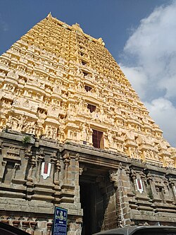
Tirukoilur also spelt as Tirukkoyilur or Tirukovilur is a city and the headquarters of Tirukoilur taluk in Kallakurichi District, Tamil Nadu, India. The town is located on the southern bank of Thenpennai River and famous for the Ulagalantha Perumal Temple, the Veerateeswarar Temple and the Kabilar Kundru. Tirukoilur is located on the highway connecting cities of Tiruvannamalai and Vellore with Southern Tamil Nadu. The town is served by Tirukoilur railway station (formerly, Arakandanallur Thirukovilur railway station).
Vanavan Mahadevi, the mother of Rajaraja Chola I, was born as a Tamil princess of Chera dynasty in Tirukoilur.
