Tofield | |
|---|---|
Town | |
| Town of Tofield | |
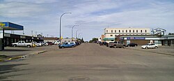
 Main street | |
Location of Tofield in Alberta | |
| Coordinates: 53°22′13″N 112°40′0″W / 53.37028°N 112.66667°W | |
| Country | Canada |
| Province | Alberta |
| Region | Central Alberta |
| Census division | 10 |
| Municipal district | Beaver County |
| Incorporated[1] | |
| • Village | September 9, 1907 |
| • Town | September 10, 1909 |
| Government | |
| • Mayor | Debora Dueck |
| • Governing body | Tofield Town Council
|
| • CAO | Cindy Neufeld |
| Area (2021)[3] | |
| • Land | 8.21 km2 (3.17 sq mi) |
| Elevation | 700 m (2,300 ft) |
| Population | |
• Total | 2,045 |
| • Density | 249.2/km2 (645/sq mi) |
| Time zone | UTC-7 (MST) |
| • Summer (DST) | UTC-6 (MDT) |
| Postal code | |
| Area code | +1-780 |
| Highways | Highway 14 Highway 834 |
| Waterway | Beaverhill Lake |
| Website | Official website |
Tofield /ˈtoʊfiːld/ is a town in central Alberta, Canada. It is approximately 68 km (42 mi) east of Edmonton at the junction of Highway 14, Highway 834, and Highway 626. Beaverhill Lake is located immediately northeast of the community.
- ^ "Location and History Profile: Town of Tofield" (PDF). Alberta Municipal Affairs. October 7, 2016. p. 653. Retrieved October 13, 2016.
- ^ "Municipal Officials Search". Alberta Municipal Affairs. May 9, 2019. Retrieved October 1, 2021.
- ^ a b Cite error: The named reference
2021censuswas invoked but never defined (see the help page). - ^ "Alberta Private Sewage Systems 2009 Standard of Practice Handbook: Appendix A.3 Alberta Design Data (A.3.A. Alberta Climate Design Data by Town)" (PDF) (PDF). Safety Codes Council. January 2012. pp. 212–215 (PDF pages 226–229). Retrieved October 9, 2013.
- ^ "Population and dwelling counts: Canada and population centres". Statistics Canada. February 9, 2022. Retrieved February 13, 2022.
