This article needs additional citations for verification. (September 2010) |
| Tohickon Creek | |
|---|---|
 A typical view of the creek from Bedminster Township. | |
 Tohickon Creek | |
| Native name | |
| Location | |
| Country | United States |
| State | Pennsylvania |
| County | Bucks |
| Township | Springfield Richland Haycock East Rockhill Nockamixon Tinicum Bedminster Plumstead |
| Borough | Quakertown |
| Physical characteristics | |
| Source | The Lookout (Springfield Township) |
| • coordinates | 40°30′35″N 75°21′37″W / 40.50972°N 75.36028°W |
| • elevation | 640 feet (200 m) |
| Mouth | |
• coordinates | 40°25′16″N 75°3′41″W / 40.42111°N 75.06139°W |
• elevation | 72 feet (22 m) |
| Length | 29.5 miles (47.5 km) |
| Basin size | 112 square miles (290 km2) |
| Basin features | |
| Progression | Tohickon Creek → Delaware River → Delaware Bay |
| River system | Delaware River |
| Landmarks | Haycock Mountain |
| Tributaries | |
| • left | Dimple Creek Haycock Creek |
| • right | Morgan Creek Threemile Run Mink Run Deer Run Wolf Run Deep Run Cabin Run Geddes Run |
| Waterbodies | Lake Nockamixon |
| Bridges | Rocky Valley Road Povenski Road Hickon Road East Cherry Road California Road East Pumping Station Road Pennsylvania Route 212 (Richlandtown Pike) Erie Road West Thatcher Road Richlandtown Road Covered Bridge Road (Sheard's Mill Covered Bridge) Pennsylvania Route 563 (Mountain View Drive) South Park Road Creamery Road Farm School Road Pennsylvania Route 113 (Bedminster Road) Pennsylvania Route 611 (Easton Road) Randts Mill Road Dark Hollow Road Stover Park Road Pennsylvania Route 32 (River Road) |
| Slope | 19.25 feet per mile (3.646 m/km) |
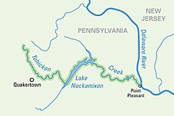
Tohickon Creek is a 29.5-mile-long (47.5 km)[1] tributary of the Delaware River. Located entirely in Bucks County, in southeastern Pennsylvania, it rises in Springfield Township and has its confluence with the Delaware at Point Pleasant. It is dammed to form Lake Nockamixon.
- ^ U.S. Geological Survey. National Hydrography Dataset high-resolution flowline data. The National Map, accessed April 1, 2011
