Tojikobod District
| |
|---|---|
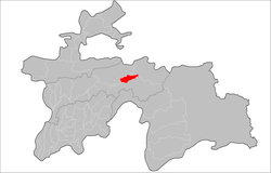
 Location of the district in Tajikistan | |
| Coordinates: 39°05′N 70°50′E / 39.083°N 70.833°E | |
| Country | |
| Region | Districts of Republican Subordination |
| Capital | Tojikobod |
| Area | |
• Total | 700 km2 (300 sq mi) |
| Population (2020) | |
• Total | 46,000 |
| • Density | 66/km2 (170/sq mi) |
| Time zone | UTC+5 |
| Official languages | |
| Website | tojikobod |
Tojikobod District (Tajik: Ноҳияи Тоҷикобод, romanized: Nohiyai Tojikobod) or Tajikabad District Russian: Таджикабад, romanized: Tadzhikabad) is a district in Tajikistan, one of the Districts of Republican Subordination. It is surrounded by Sangvor District from the south, Lakhsh District from the north-east, and Rasht District from the north-west. Its capital is the village Tojikobod. The population of the district is 46,000 (January 2020 estimate).[2]
- ^ "КОНСТИТУЦИЯ РЕСПУБЛИКИ ТАДЖИКИСТАН". prokuratura.tj. Parliament of Tajikistan. Retrieved 9 January 2020.
- ^ "Population of the Republic of Tajikistan as of 1 January 2020" (PDF) (in Russian). Statistics office of Tajikistan. Retrieved 13 October 2020.